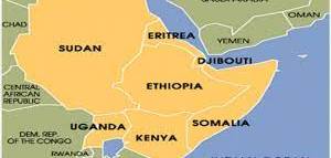
We regularly witness with the same heartbreak the same tragedy: a meteorological cycle that brings terrible drought and famine to East Africa; threatening the lives and livelihoods of millions of people in Ethiopia, Somalia and Kenya.
The meteorological cycle responsible for these episodes is called: "La Niña" ; a phenomenon reinforced by climate change. La Niña is driven by cooling ocean temperatures in the eastern part of the Pacific, causing, among other things, periods of drought in East Africa.
Human-induced warming in the western Pacific Ocean is making matters worse. Global emissions have caused the western Pacific to warm rapidly, leading to more rain around Indonesia and worrying but predictable rainfall deficits in areas further east such as Kenya, Somalia and Ethiopia , parts of the world already prone to arid and food insecure conditions.
As described in the book, Drought Flood Fire , East Africa typically receives two rainy seasons each year, from October to December and from March to May. Now, with climate change, we are seeing more erratic, frequent and extremely dangerous water stress episodes.
Prior to 1999, a drought - a poor or failed rainy season - could occur once every five or six years. But since 1999, bad rains from March to May occur every two or three years.
From 2010 to 2011, consecutive droughts helped push Somalia into famine. Over 260,000 people died, half of them children. Then, in 2016/2017 and 2020/2021, consecutive droughts hit the region again.
Fortunately, we can now often predict these droughts using climate models and Earth observations.
For example, a group of scientists have sounded the alarm and predicted that food security in the Horn of East Africa is likely to deteriorate in 2020, due to below-average rainfall in the coming months. We made it through the network of early warning systems ( Famine Early Warning Systems Network ) against famine, one of the leading suppliers early warning and analysis of acute food insecurity in world.
Feelings are, however, mixed on this subject: it is welcomed that the information can help identify food insecure populations before a disaster strikes, but it is regretted, of course, that such populations at risk. exist.
Scientists now believe that a devastating drought is likely to recur in 2021/2022. The sea surface temperature forecast looks almost exactly the same as last year, and we expect unusually warm conditions in the western Pacific Ocean, combined with cool La Niña temperatures in the eastern Pacific, are likely to produce another sequence of dry seasons.
Kenya has already declared a drought emergency. With more drought shocks likely on the horizon, it will be important for governments and other actors to be proactive.
Without effective early action, all data collection and modeling is of limited value, and people end up in pain.
Prediction possibilities
As part of the Famine Early Warning Systems Network, the Climate Hazards Center produces rainfall estimate maps that help guide billions of dollars in humanitarian aid for tens of millions of people.
In general, climate models can predict where exceptionally warm water will be. And we can use these predictions to diagnose droughts, often before they happen.
For example, when the eastern Pacific is warmer, it magnifies the intensity of droughts in northern Ethiopia and southern Africa. While this extra heat is found in the western Pacific and eastern Indian Ocean, it contributes to sequential droughts in Kenya, Somalia and southern Ethiopia.
Understanding how climate change affects unusually warm ocean conditions helps scientists make these predictions. And that means that it becomes possible to help anticipate food insecurity.
In 2016-2017, they used observed sea surface temperatures to help motivate a joint alert that helped improve humanitarian responses; When the 2017 rains failed in Somalia, aid was already arriving for millions of people.
Now, in 2021/2022, scientists are using La Nina's analogues and long-range predictions of western Pacific Ocean conditions to make drought predictions even further ahead; anticipating that the rainy season from March to May 2022, which will end eight months later, will likely be bad.
Our ability to make accurate and useful climate predictions is improving, but much remains to be done.
What needs to change
The information that is produced can, and is, used to help motivate drought risk management activities. For example, in 2015 and 2018, correct predictions from the El Niño study successfully confirmed that no water would fall in the rainy season in southern Africa.
But there is still a lot to do. The management of drought risks rests on three pillars; drought monitoring and forecasting, vulnerability and risk assessment and drought preparedness, as well as mitigation and response.
It seems that at this point the first pillar has progressed more than pillars two and three.
Other interventions are needed to mitigate the disruptive effects of droughts. This would lead to severing the link between climate shocks and cycles of poverty.
Here are some examples of early measures:
- provide money to vulnerable farmers and herders,
- distribute drought-resistant seeds,
- carry out health campaigns to improve animal health,
- provide additional feed for livestock,
- provide schools with drinking water;
- help families with cash payments so they can afford to leave their children in school.
Nonetheless, there have been some exciting developments.
Aid agencies, such as the United Nations Office for the Coordination of Humanitarian Affairs (UNOCHA) and the Red Crescent, are beginning to test “early action” systems that proactively use forecasting. For example, UNOCHA is working with the Ethiopian government to implement a framework for “anticipatory action”.
Another path to greater resilience is to improve agricultural decision-making. In 2020, the Climate Hazards Center began working with Plant Village, the Kenya Meteorological Department and ShambaShapeUp to begin providing rainfall observations, forecasts and agricultural advisories to hundreds of thousands of Kenyan farmers. This has been done by text message and to millions of Kenyans via television. In 2021, PlantVillage's reach expanded to include breeders.
As described in Drought Flood Fire , climate change amplifies the capacities of El Niños and La Niña to cause drought. The next five years will most likely bring a strong El Niño, contributing to another terrible drought in northern Ethiopia and another drought disaster in Zimbabwe, Zambia, Botswana, Mozambique, Madagascar and South Africa. South. Next year looks likely to bring another streak of La Niña-related droughts to East Africa.
Regional institutions - such as the Intergovernmental Authority on Development (IGAD) Climate Prediction and Applications Center, the Southern African Development Community Climate Services Center - and some national meteorological agencies are making great efforts. progress in drought monitoring and forecasting. It is to be hoped that the information they provide can be transformed into appropriate action.
Now is the time to begin this transformation. Historical precipitation data can be used to identify areas at risk, thus guiding drought preparedness. We must move from crisis management to risk management.
Sources:
 Chris Funk - Director of the Climate Hazards Center, University of California Santa Barbara
- Book: Drought Flood Fire.
Posted on 2021-10-12 11:05


Comments